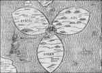
Heinrich Bünting, Die gantze Welt in ein Kleberblat (The Whole World in a Clover Leaf), from Itinerarum sacrae scripturae (Helmstadt: Siebenburger, 1581). Courtesy of Map Collection, Yale University Library
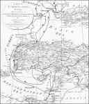
Rabbi Nahman’s pilgrimage to the Holy Land in 1798–99, based on Samuel Dunn’s map Turkey in Asia, in A New Atlas of the Mundane System (London: Sayer, 1788), plate 23, with approximate route added by Joseph Stoll, Syracuse University Cartographic Laboratory, in collaboration with Ken Frieden
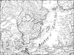
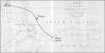
Euchel’s route from Königsberg to Copenhagen by way of Gdansk (Dantzick), 1785, based on Samuel Dunn, The Northern States, in A New Atlas of the Mundane System (London: Sayer, 1788), plate 10, detail, with Euchel’s approximate route added by Joseph Stoll, Syracuse University Cartographic Laboratory, in collaboration with Ken Frieden
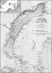
Nova Zembla showing the routes taken by Captains Willem Barents and Jacob Heemskerk, compiled by S. R. van Campen, from J. K. J. de Jonge, Nova Zembla (1596–1597): The Barents Relics, trans. Samuel Richard van Campen (London: Trübner, 1877), modified by Joseph Stoll, Syracuse University Cartographic Laboratory, in collaboration with Ken Frieden
Chart of the Pelew Islands and Adjacent Seas, and detail, from George Keate [and Henry Wilson], An Account of the Pelew Islands, Situated in the Western Part of the Pacific Ocean, 2nd ed. (London: Nicol, 1788), with Captain Wilson’s approximate route added by Joseph Stoll, Syracuse University Cartographic Laboratory, in collaboration with Ken Frieden